


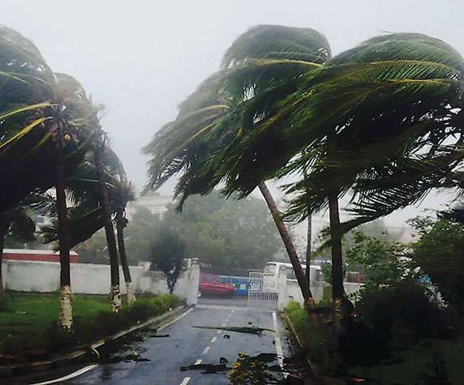
New Delhi: The India Meteorological Department (IMD) is on the verge of announcing the onset of the monsoon over Kerala within the next 48 hours. However, climate scientists and meteorologists are cautioning that the monsoon’s arrival is anticipated to be weak, with the weather system’s progress across the country likely to be sluggish during its initial week.
According to IMD’s bulletin on Wednesday, the mild onset is attributed to the influence of Cyclone Biparjoy, which has developed in the Arabian Sea. The bulletin stated, “Latest meteorological features associated with monsoon onset over Kerala show: there is persistence of westerly winds over the south Arabian Sea, an increase in the depth of westerly winds up to middle tropospheric levels, and an increase in cloudiness over the areas covering the southeast Arabian Sea, Lakshadweep, and Kerala coasts. Under such a scenario, conditions are becoming favorable for monsoon onset over Kerala during the next 48 hours.”
However, experts are warning that the monsoon may not bring substantial rainfall in its initial phase. The severe cyclone, Biparjoy, has already delayed the monsoon by a week, and there are concerns that its impact may further hinder the progress of the monsoon.
Mahesh Palawat, Vice President of Climate and Meteorology at Skymet Weather, explained, “We can expect a weak onset. Some rainfall over parts of Kerala is also a result of the cyclone, which is pushing moisture towards the west coast due to its large size. Over the next two to three days, westerly winds may pick up, and cloud cover may increase as the cyclone moves northwards and gathers moisture from its surroundings. Although the monsoon onset may not meet all criteria, it can still be considered if key parameters are present. Therefore, a weak onset can be expected around June 9. However, proper rainfall in interior areas may not occur until June 12-13.”
Experts believe that farmers should consider delaying their sowing activities by a week or 10 days due to the expected delay and below-normal rainfall in June.
Roxy Mathew Koll, a climate scientist at the Indian Institute of Tropical Meteorology, pointed out, “Since the cyclone is located away from the coast and is absorbing a significant amount of moisture, monsoon rains may not be widespread, at least during the current week. It is not a typical monsoon onset. The rainfall observed over Kerala is the monsoon system picking up the remaining moisture from the cyclone.”
Weak Monsoon Onset Expected in India as Cyclone Biparjoy Delays Progress
Furthermore, there are concerns that the overall monsoon season may be disappointing this year. Pushpendra Johari, Senior Vice President of Sustainability at RMSI, a global disaster risk management firm, stated, “The monsoon is already delayed over Kerala, and we have not observed the high temperatures in North India that are typically experienced in May-June. These high temperatures usually lead to the formation of a low-pressure area in the north, which attracts monsoonal winds. RMSI’s assessment suggests a 30-40% probability of moderately deficient rainfall in states such as Western Uttar Pradesh, Punjab, Haryana, and Delhi NCR.”
However, there is a minority viewpoint suggesting that the monsoon onset will be normal. M Rajeevan, former Secretary of the Ministry of Earth Sciences, stated, “The cyclone will not seriously hinder the onset process. As conditions become more favorable, IMD has indicated that the Kerala onset is imminent. By June 10, conditions will improve significantly as the cyclone moves away. Monsoon may even reach Karnataka. By the time the cyclone dissipates, the Bay of Bengal will also become highly active. Therefore, the onset process will be smooth for the next four to five days.”
Weak Monsoon Onset Expected in Kerala due to Cyclone Biparjoy, Caution Climate Scientists
Experts have noted the rapid intensification of Cyclone Biparjoy, attributing it to the very warm Arabian Sea. Vineet Singh explained, “Cyclone Biparjoy rapidly intensified from a deep depression to a very severe cyclone in just 24 hours, which is an increase in wind speed of 65 kmph. This rapid intensification is due to high sea surface temperatures, which are 2-3 degrees above normal, and high ocean heat content. Additionally, favorable upper atmospheric outflow and moderate wind shear have facilitated the system’s rapid intensification.”
There is a growing realization that the Arabian Sea is being impacted by climate change, leading to an increase in cyclone activity. Roxy Mathew Koll tweeted, “The increase in cyclone activity in the Arabian Sea is tightly linked to the rising ocean temperatures and increased availability of moisture under global warming. The Arabian Sea used to be cool, but now it is a warm pool.”
As of Wednesday evening, Cyclone Biparjoy had intensified into a very severe cyclone with winds clocking between 120 to 130 kmph, gusting up to 145 kmph over the east-central Arabian Sea. It was positioned approximately 860 km west-southwest of Goa, 940 km southwest of Mumbai, 1000 km south-southwest of Porbandar, and 1300 km south of Karachi. The cyclone is expected to intensify further and move northwards in the next 12 hours before changing direction to a north-northwestward trajectory over the subsequent three days.


